
Summary
The 2025 Canadian wildfire season is already causing serious air quality issues, not just in Canada, but across the U.S. and even Europe. This blog breaks down how wildfire smoke spreads, what harmful pollutants it carries (like PM2.5, CO, VOCs, and ozone), and why monitoring it in real time is more important than ever.
We explore how modern tools like IoT-based sensors, satellite data, and localized AQI alerts are helping experts track the smoke’s impact minute by minute. You’ll also see how Oizom’s Polludrone stands out in this space with its accurate, real-time data and lab-tested reliability.
From short-term health risks to long-term policy changes, this blog covers what professionals in air quality, public health, and urban planning need to know. If you care about clean air and smarter environmental response, this read is worth your time.
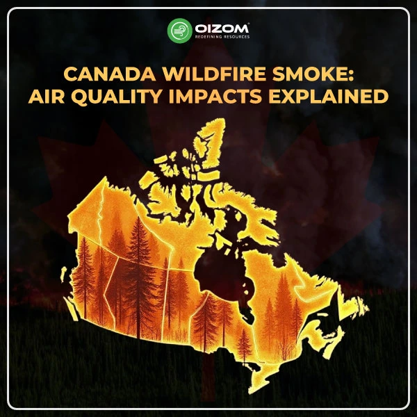
Canada Wildfire Smoke: Air Quality Impacts Explained
Wildfire smoke doesn’t just stay where it starts. It spreads fast, changes the air we breathe, and brings serious pollution with it.
Canada’s 2025 wildfire season is already showing widespread impact. Thick smoke is moving across provinces and even reaching other countries. But what’s more concerning is what we can’t see: harmful pollutants like PM2.5 (fine particles), VOCs (volatile organic compounds), and ground-level ozone (O₃) forming in the atmosphere.
As air quality professionals, we know this isn’t just about visibility or smell, it’s about data. From real-time sensor networks and IoT-based monitors to satellite tracking, we now have tools to measure exactly how smoke is affecting the air, moment by moment, place by place.
In this blog, we’ll explore the ongoing wildfire smoke situation in Canada from an air quality perspective. You’ll find data-backed insights on pollutant trends, monitoring approaches, health risks, and what these events mean for future planning and response.
Whether you’re managing monitoring stations, working in policy, or analyzing air pollution data, this breakdown offers a clear look at how wildfire smoke is reshaping our understanding of air quality in 2025.
Understanding Wildfire Smoke Composition
Wildfire smoke isn’t just about what we see in the sky. It’s about what we breathe. And as the 2025 Canadian wildfire season unfolds, that smoke is traveling farther and affecting more people than ever before. From Europe to the U.S. and across Canada, hazy skies are a visible reminder of a much deeper air quality challenge.
Let’s unpack what’s actually in wildfire smoke and why monitoring its components matters.
What’s in Wildfire Smoke?
Smoke is a mix of gases and fine particles produced when organic material burns. In Canada’s current wildfire crisis, emissions come from burning forests, peatlands, and sometimes even urban infrastructure, meaning the composition varies across regions and fires.
This smoke contains:
- Carbon-based particles, like black carbon and organic carbon
- Gaseous pollutants, such as carbon monoxide (CO)
- Chemical compounds, including VOCs and nitrogen oxides (NOx)
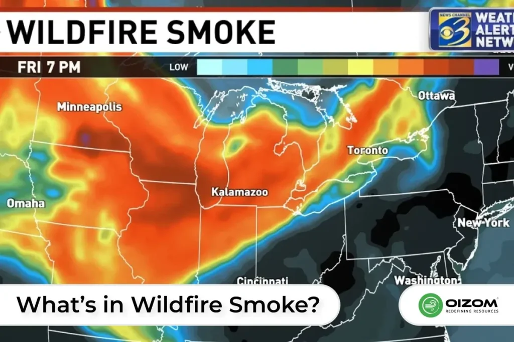
These pollutants can travel thousands of kilometers. For example, data from Copernicus Atmosphere Monitoring Service confirms that smoke plumes from Canadian wildfires recently reached Europe, highlighting how widespread the impact can be.
Key Pollutants: PM2.5, CO, VOCs, and O₃
- PM2.5: Ultrafine particles that enter deep into the lungs. Air quality maps from CBS News show alarming PM2.5 spikes across US cities downwind of Canadian fires.
- CO (Carbon Monoxide): Produced in large amounts during smoldering phases of fire, especially in peat-rich boreal zones.
- VOCs: Includes chemicals like benzene and formaldehyde, contributing to secondary pollutant formation.
- O₃ (Ground-level Ozone): Forms when sunlight triggers chemical reactions between VOCs and NOx, especially on hot days. Elevated ozone levels have been recorded across regions like Colorado and the Northeastern U.S. (Conway Daily Sun).
Short-Term vs Long-Term Exposure Risks
- Short-Term: Respiratory irritation, asthma flare-ups, headaches, and fatigue. Sensitive groups like children, seniors, and outdoor workers are hit hardest.
- Long-Term: Chronic exposure to wildfire smoke can lead to cardiovascular disease, decreased lung function, and increased mortality, as noted by Daily Climate.
Real-time monitoring and early alerts are essential for tracking these risks and guiding mitigation strategies.
What’s Causing Canada’s 2025 Wildfires?
Extensive, widespread wildfires have been burning across the Canadian provinces of Alberta, Manitoba, and Saskatchewan since May 2025. One of the biggest reasons behind this year’s wildfires in Canada is something called “zombie fires.” These are fires that didn’t fully go out last year. Instead, they kept burning slowly underground through the winter, especially in areas with peat-rich soil. When warmer weather returned in spring, these hidden fires flared up again and started new wildfires, long before the usual fire season even began.
Along with zombie fires, climate change is making everything worse. Canada is warming about twice as fast as the global average. That means hotter days, drier forests, and less snow to keep the ground moist. So when fires start, whether from lightning or human activities like campfires or machinery, they spread much faster.
In 2025, we’re seeing wildfires grow bigger, start earlier, and last longer. This makes the air quality problem much more serious and harder to predict.
As an air quality researcher, it’s important to understand that the smoke we’re measuring today is part of a bigger pattern. The combination of remaining underground fires and extreme weather is creating a longer and more dangerous wildfire season. And that means air quality monitoring is more critical than ever.
Real-Time Air Quality Data from Canada
As Canada’s 2025 wildfire season intensifies, air quality data is doing more than just capturing numbers; it’s becoming the frontline for decision-making. From government agencies to citizen-led sensors, real-time data is helping us understand how smoke is moving, what pollutants are spiking, and where interventions are most needed.
Air Quality Monitoring Sources (Government, Citizen, IoT)
Canada’s air quality network is now more layered than ever. At the federal level, Environment and Climate Change Canada (ECCC) operates a network of reference-grade stations reporting hourly AQI, PM2.5, O₃, CO, and NO₂ levels. Alongside, satellite-based models like those from Copernicus CAMS provide transboundary smoke transport data, confirming that Canadian smoke has even reached Europe.
Let me share a quick story. While I was researching the Canada wildfire smoke, I happened to check the air quality in Zurich, and I was genuinely surprised. It turns out, the smoke from the wildfires has travelled all the way across the Atlantic and is now drifting over parts of Central Europe, including Switzerland. I didn’t expect it to reach that far! A good example of transboundary air quality.
On the ground, citizen science platforms like Airnow and IoT-based sensor networks are filling spatial gaps, especially in remote or rural communities. These low-cost monitors, though not regulatory-grade, offer granular, hyperlocal data that can detect sudden PM2.5 spikes faster than some traditional systems.
Want to keep an eye on air quality in real time? With Oizom’s Polludrone, you don’t have to worry, it delivers accurate, real-time air quality data you can rely on. Why does Polludrone truly stand out in the air quality monitoring market?
Because we don’t just build monitors; we build trust in data. Every Oizom air quality monitoring device is first calibrated in an ISO/IEC 17025:2017 certified lab using NIST-traceable gas standards, strictly following international guidelines (U.S. EPA Vol II, Section 6.0 Rev.1).
But we don’t stop there.
After lab calibration, each device goes through a second level of testing, collocation with a custom-built reference station equipped with U.S. EPA-designated Federal Equivalent Method (FEM) analyzers. This double-layered approach ensures that Polludrone delivers data you can depend on every single time.
At Oizom, we take data accuracy seriously. Our Polludrone Smart has undergone rigorous field evaluations, including benchmarking by third-party validation programs like AQ-SPEC (Air Quality Sensor Performance Evaluation Center) by South Coast AQMD.
Want to see how it performs in real-world conditions? Click the link above to explore the detailed field evaluation report and discover why Polludrone Smart stands out in accuracy and reliability.
Trends in PM2.5 and AQI Across Provinces
So far in 2025, PM2.5 concentrations have surpassed 150 µg/m³ in several regions, particularly in Alberta, British Columbia, and parts of Ontario. That’s more than 6 times the WHO 24-hour limit.
AQI levels in major cities like Toronto and Calgary have been oscillating between “Unhealthy” to “Very Unhealthy,” as visualized in maps from CBS News. Meanwhile, U.S. cities like Denver and Boston are also reporting hazy skies and elevated AQI due to transported smoke.
How 2025 Compares to Past Wildfire Years?
Compared to 2023, this year’s wildfire season has started earlier and appears more severe. In 2023, wildfires burned over 18 million hectares, marking a record high. Yet in 2025, experts say smoke density and atmospheric spread have intensified, likely due to persistent high-pressure systems and warming trends.
As Daily Climate notes, changing climate patterns are leading to longer, more intense fire seasons. The result: more frequent air quality alerts, rising public health concerns, and growing pressure on monitoring networks to respond faster and more accurately.
Health Impacts and Public Alerts
Wildfire smoke doesn’t just cloud the skies, it affects our health, often in ways we can’t immediately see. While short-term exposure can irritate the eyes and lungs, long-term exposure increases the risk of serious respiratory and cardiovascular problems. That’s why timely alerts, public advisories, and access to reliable air quality data are so important, especially for people most at risk.
Vulnerable Populations
Not everyone feels the impact of wildfire smoke the same way. Groups at higher risk include:
- Children, whose lungs are still developing
- Older adults, particularly those with heart or lung conditions
- People with asthma or COPD
- Outdoor workers and athletes
Even healthy individuals can experience symptoms like coughing, throat irritation, or shortness of breath during high-smoke events. In recent weeks, Canadian and U.S. cities have issued health alerts as PM2.5 levels have soared past safe limits, according to CBS and 9News.
Indoor vs Outdoor Exposure
Most people assume staying indoors is enough, and often, it does reduce exposure. But the reality is, smoke can still seep inside through doors, windows, and ventilation systems. Without air purifiers or sealed environments, indoor PM2.5 levels can reach up to 70% of outdoor concentrations during severe smoke events.
Using HEPA filters, sealing windows, and keeping indoor activities low-impact can help. Monitoring indoor air with low-cost sensors is also gaining popularity, especially in schools, offices, and hospitals.
Worried about what your kids are breathing at school during wildfire season? You’re not alone, and you’re in the right place.
Meet Oizom’s Polludrone, a smart air quality monitor that gives you real-time data on what’s really in the air. It measures all the key pollutants defined under the National Air Quality Index (NAQI), so you get a complete and accurate picture.
Polludrone is built with advanced technology that makes monitoring more reliable:
- E-breathing system for better air sampling
- Humidity correction for accurate particulate matter readings
- Anti-static inlet to prevent data errors from particle loss
Whether it’s wildfire smoke or everyday pollution, Polludrone helps schools and parents stay informed and take action. Because clean air isn’t optional, especially for growing children.
Advisory Protocols and Response Measures
Public health agencies now rely on AQI-based alert systems to guide community response. These alerts are often color-coded and suggest actions like:
- Avoiding strenuous activity outdoors
- Wearing N95 masks
- Using air purifiers indoors
- Delaying outdoor events or school recess
Platforms like local air quality apps push real-time updates. However, consistency and accessibility of these alerts still vary by region. As Daily Climate highlights, there’s growing demand for faster, localized warnings based on sensor networks and predictive models.
Technology in Smoke Monitoring
Understanding wildfire smoke requires more than just looking at the haze, it needs data, precision, and the right tools. Thankfully, modern technology is giving us a better way to monitor, predict, and respond to smoke events. From IoT sensors on the ground to satellites in space, these tools are shaping how we track and manage air quality in real time.
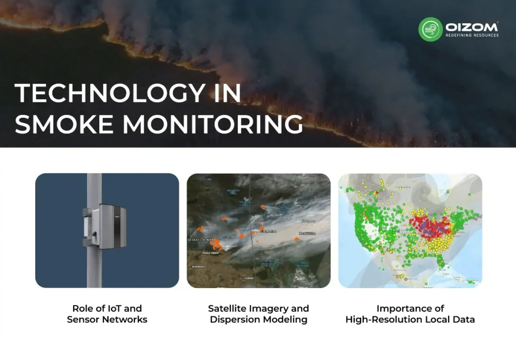
Role of IoT and Sensor Networks
IoT-based air quality monitoring has become popular, especially during wildfire events. These small, connected devices collect data on pollutants like PM2.5, CO, and VOCs in real time, helping detect local spikes that traditional stations might miss.
Networks like Oizom’s Polludrone use active sampling methods and real-time calibration algorithms to provide accurate data even in extreme environments. With cloud connectivity, data is instantly available to authorities, schools, industries, and even the public, allowing quicker decisions like issuing alerts or adjusting outdoor activities.
Want to see how Polludrone works in real-world conditions? Check out our case study on detecting forest fires through air quality monitoring in Portland, US.
These low-cost, distributed sensors complement government monitoring stations by filling spatial gaps, particularly in rural or high-risk zones.
Satellite Imagery and Dispersion Modeling
Satellites play a crucial role in giving the big picture. Platforms like Copernicus CAMS track smoke plumes as they travel across provinces and even continents. Recent data confirms that smoke from Canada’s 2025 wildfires has already reached parts of Europe.
Satellites use aerosol optical depth (AOD) to estimate pollutant concentration, which is then fed into atmospheric dispersion models. These models help forecast where the smoke will go next and how intense it might become, critical for public safety and planning.
Importance of High-Resolution Local Data
While satellite data gives scale, high-resolution local monitoring gives clarity. Wildfire smoke can vary block to block based on wind, topography, and local emissions. This is where IoT sensors shine, providing minute-by-minute data that can support hyperlocal alerts and targeted interventions.
Combining satellite insights with ground-level data ensures that response efforts are both broad and precise, and that no community is left guessing.
Policy, Preparedness, and Mitigation
As wildfire seasons become longer and more intense, policies around air quality can no longer stay reactive. Governments and cities must move from short-term advisories to long-term strategies that include data-driven planning, cross-agency coordination, and climate adaptation. Let’s look at how current standards are being tested, what we’ve learned from recent years, and how we can better prepare for what’s ahead.
Air Quality Standards and Exceedances
Canada and the U.S. follow established air quality standards based on pollutant thresholds, like the 24-hour PM2.5 limit of 25 µg/m³ (WHO) or 35 µg/m³ (U.S. EPA). However, during wildfire events, these limits are frequently exceeded for days at a stretch. In the current 2025 season, cities like Calgary and Toronto have recorded PM2.5 levels above 150 µg/m³, pushing AQI values into “Very Unhealthy” territory, as reported by CBS.
The challenge is that while the standards exist, there are limited mechanisms for enforcement or mitigation when violations are caused by natural events like wildfires. This is pushing agencies to reconsider how exceedances are reported and how public health risks are managed.
Lessons from 2023–2024 Wildfire Seasons
The past two wildfire seasons highlighted some critical gaps. Despite advances in monitoring, public communication was often delayed or inconsistent. In 2023, smoke from Canadian wildfires disrupted air quality across New York, Chicago, and even parts of Europe, yet response protocols varied widely between jurisdictions.
One key takeaway: real-time data must feed directly into public action. Delays in translating high PM2.5 readings into advisories left many vulnerable communities exposed. Another lesson was the importance of cross-border data sharing, especially for plume movement and health impact forecasting.
Path Forward: What Governments and Cities Can Do
To stay ahead of the curve, governments must invest in:
- Integrated air quality platforms that merge satellite, ground, and model data
- Early warning systems with automated alerts
- Mobile monitoring units to reach underserved areas
Cities can also update building codes to improve indoor air quality in public facilities, install community-level air sensors, and run awareness campaigns during wildfire seasons.
Ultimately, preparedness means moving beyond seasonal alerts toward year-round resilience planning, because wildfire smoke is no longer a rare event, but a recurring public health challenge.
Conclusion
Wildfire smoke is no longer a seasonal concern, it’s becoming a year-round air quality threat. The 2025 Canadian wildfire season has once again shown how fast smoke can travel, how high PM2.5 levels can spike, and how urgently we need reliable monitoring and timely action.
From IoT sensors and satellite data to real-time AQI alerts, technology is giving us the tools to see the invisible. But knowing the data is just the first step. The real value lies in how we use it, to protect vulnerable groups, guide public decisions, and shape stronger air quality policies.
As wildfires and air pollution become more closely linked, the focus needs to shift from reacting to preparing. This means improving high-resolution monitoring, building early-warning systems, and investing in cleaner, climate-resilient infrastructure. The air may look clear, but the data often tells a different story, are we listening?
For air quality professionals, the message is clear: wildfire smoke isn’t just an environmental issue, it’s a public health and data challenge. Addressing it means embracing smart tech, fostering collaboration, and promoting informed strategies that prioritize how to protect from wildfire smoke in both short-term events and long-term planning.
FAQs
Wildfire smoke lowers air quality by releasing harmful pollutants like PM2.5, CO, and VOCs. It causes AQI levels to rise quickly, leading to health risks even far from the fire.
Wildfire smoke contains PM2.5, carbon monoxide (CO), volatile organic compounds (VOCs), and ozone-forming gases like NOx.
You can track air quality using real-time data from platforms like AirNow, CAMS, or local government websites. Look for PM2.5 and AQI updates.
PM2.5 is the most harmful pollutant in wildfire smoke. These tiny particles penetrate deep into the lungs and can cause serious health issues.